Update October 2023
Strava have now enabled the use of Cuepoints in their route planner. Full details on using these here STRAVA Note how they call them Waypoints which by a GPX definition they most definately are not. If you exported from there as a GPX there would be no waypoints/Cues. The file must be used as a TCX or FIT file. Oh and you have to be a fully paid up member. For that price RWGPS is way better
Update – April 2022:
There is now another way to add Cue points to Wahoo for free using the very good route planning site https://cycle.travel/map After a discussion with the wonderful creator of the site Richard he was happy to add a way to add Cue points to a TCX file.
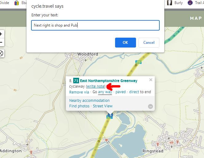
This is a very good route planner, and it can be staggering how quickly it can calculate and re-calculate a route. the owner has designed it to look for cycle friendly routes. Create a route by simply clicking spots on the map and dragging them to change the route. To add a cue point just click on your route and “Add via point” This creates a numbered point on the route. then click on it again and you get the pop up shown above. Then click the “write note” control and you then add your cue into the text window.
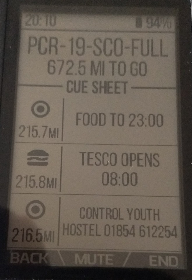
There is no option to add any different cue graphics, only the simple point graphic is shown on the Wahoo devices. Your cues are shown on the cycle travel site in the list of turn by turn instructions. Unfortunately it is not possible to remove all or any other of the turn by turn comments from your downloaded TCX file.

To save the TCX route file use the GPS button in the route tools, click “Download Options” and select the TCX download option. You have an announce instruction option too. Simple and very effective.
Try the option button to Find hotels and campsites near the route, which links into other services and shows well on the map. For UK users If you support the site with a small fee you get access to Ordnance survey maps.
If you would like a very good video tutorial of how to use the sites many tools, check out this video from the creator. Cycle.travel explained. Thanks to Richard for all his help, hope this is useful.
The All Trails site that has taken over the original GPSies site, that this was written for , this has changed for the worse and will not work as well as it originally did.
For a short video of the best way using Ride With GPS – see here – Utube Video
Riders in Adventure bikepacking races can benefit from adding waypoints on Garmin devices, but this is harder to do with Wahoo devices like the ELEMNT. RidewithGPS will do this for you very well indeed, and if you are prepared to pay the $80 a year then it’s by far the best option. GPSies.com was a great tool to allow you to do this for free but it has now been taken over: Here is a help guide, and aid memoir for me, in how to do this. (updating for the new owner – All Trails)
To start with there are two methods to create a route, from the main menu from scratch or the option to UPLOAD a route. Initially we will create a simple route and add several Cue points. This allows the user to do some simple tests around their home before a big ride or Endurance event when you will be uploading a set route or one planned on another platform.
Cue points on a created Track
All Trails does not seem to deal in tracks or routes, they call their design area MAPS. Select PLAN then CREATE MAP then select the DRAW ROUTE button.
- Search for your start location to centre the map
- Select the routing software type, road. MTB, touring to use
- Click points on the map for the route to be drawn, map layers can be changed to suit locations and try the overlays like Waymarked cycling.
- Select save map, did not ask for a title or name
- On the left hand side you can now add Waypoints as shown below

The waypoint appears on the map in the centre as a purple dot; click and drag it to the correct location (very good) and it can be named with a description. Show Title when ticked makes it visible on the map. Here I added three waypoints, they can be edited or re-ordered after creation.
The NAME part of it is for your reference only. This is the part that a GPX file relies on. For the TCX when uploaded to the Wahoo device the DESCRIPTION part is what will appear on screen. This is important if you do not enter any text in the DESC field then you will have no text on screen. You can write information about shops, etc it will display quite alot of characters.

Download the route as the type .TCX which then exports the route and the waypoints together.
Cue icons are no longer supported – there is progress for you.
You then have two options to load it to your Wahoo which might be alien to you if you normally just sync your rides from RidewithGPS or Komoot.
- Load via email. This is my preferred option and also allows you to keep a backup of any route you use in your email system if your device crashes. 1. Email the file to yourself 2. Fire up your Wahoo device and enable the bluetooth on your phone to pair them. 3. Open the email on your phone and select download the TCX file. On my Android phone it asks if you want to import into the Wahoo ELEMNT app, which I OK. 4. The Wahoo app opens and you need to hit SELECT ROUTE highlighted in blue and the file is loaded to the wahoo device.

- Load direct from Your PC. Plug your Wahoo into the PC and power up the device to have it recognised to view its contents. the folder USB_storage-Routes are where USB loaded rides are stored. Delete any you no longer require here, and place your new demo route here. (Note: while you are here its a good idea to clear out the exports folder of old rides to save device space as you have probably synch’d all your rides to save them. Power off the Wahoo before disconnecting it.
- Power back on the Wahoo and navigate to the route display. Select Sync and the ride will appear in the list. It will show as a USB ride rather than one denoted by Wahoo (loaded from the app) or Komoot/RWGPS/Strava if loaded from there.
Checking out the route for the Cue points
With your Wahoo ELEMENT on the map page > select ROUTE and the new route, if not already selected can be chosen. The CUE points are then shown in the list when Route is pressed again. Does it use Icons? Use the up/down buttons to scroll through the list. Ultimately go out and do the test ride to see the Cue points in action for real.
Dont forget the DESCRIPTION field box is the main body of text that appears on the Wahoo, so either leave the waypoint name as WP1 etc. in Alltrails or change it for reference only while planning.
THE FOLLOWING IS OLD INFORMATION WHICH ONLY WORKED WITH GPSIES
That’s progress for you, this used to work brilliantly.
The following Ten waypoints had been tested and show up with a symbol in the ELEMENT, most just display a dot so again are only of use on the mapping design stage if used.
- GENERIC – The one to use for a Dot Icon
- SUMMIT appears as a mountain Icon
- VALLEY appears as a valley Icon
- MOUNTAIN PASS – dot only
- WATER appears as a water tap icon
- FOOD appears as a burger Icon
- DANGER appears as a warning triangle
- FIRST AID appears as a Cross Icon
- SPRINT appears as a jersey icon with S on.
- STRAIGHT appears as an up arrow icon
- All the 3 LEFT ones appear as same Left icon
- All the 3 RIGHT ones appear as same Right icon
- U TURN, RESIDENCE, LODGINGS, PARKING, STATION, ATTENTION, INFORMATION, VIEWPOINT, SIGHTSEEING, BAR-B-Q, CAMPGROUND, GEOCACHE, ZOO, SWIMMING, SERVICE STATION, are all just dot icons.
- The end of a route has a Flag Icon.
Cue points on a loaded pre-made GPX Track
This could be any compatible track provided for an endurance event or created by yourself in the route tool of your choice and you just wish to add feed-zone points of Cafe stops. Note: If you are used to creating GPX tracks with embedded GPX waypoints these will be imported all ready to use, so you can use GPSies as just a conversion tool from GPX to TCX for the wahoo devices.
From the top menu its PLAN -> CREATE MAP again then use the UPLOAD FILE link and click and drag your ride GPX, TCX or any format supported into the box. It will be shown as a thumbnail. Then hit UPLOAD.
I uploaded a GPX with many waypoints and then selected the Show All Titles option at the bottom of the waypoint list.
Further notes about other capabilities of the GPSies tool some may be still available in All Trails – to be investigated.
- You can compare routes in GPSies, two or more routes are then shown on the same map in different colours.
- You can print a pdf of route (waypoints don’t show though)
- Seperate tracks into groups to easily find them and quick comparisons.
- There is a handy map over view of all your routes on a European map in either all tracks view or within a group.
- Multiple route download is available for backups or transferring.
- Tick the remember route and it appears in the list titled NOTES for quick find option, like a favourites folder.
- VERY USEFULL: You can use a downloaded route as a template. the editor then opens with this route in the background in purple; You can then try variations by using this as a guide. Great for making similar routes or adding diversion or option routes. Brilliant.
Handy Hints:
- To delete routes from the Wahoo ELEMNT App – View Routes > Then just swipe the route Left, next Synch it will be removed.
- Routes from an external source cannot be deleted unless you delete them in Komoot/RWGPS/Strava. If you want to keep an extensive route library in one of these tools then don’t sync the device, and load via email/Wahoo app or USB load. (what a very poor software design)
Please comment on anything that could improve this guide as I have only borrowed a Wahoo device.
There is a nice tool for modifying files which is detailed in this post TOOLS

think I need to re-write this for the All-trails site now they have taken over gpsies, looks like it still works luckily
how you do it on the All-trail. The free version does not work for me.
Hello. Really thanks for an article. Helped me a lot. I’m currently testing it. Route downloaded as tcx file and sent to element bolt by email does not show me any cues. But uploaded (file downloaded from alltrails) to ride with gps site and then sent to bolt just by synchronization, works super fine. Regards
Interesting, I have been having problems with cues from Alltrails lately and wondered if Wahoo had changed something in the software. I even paid for a few months of RWGPS to check things and got it to work again. Something has changed as it is not as easy as before.
I will have to try an upload from Alltrails to RWGPS as when on the road I prefer to load using the direct sync mode to the wahoo.
Finally found someone else who knows it used to work perfectly, then Wahoo did something to stop it, has a suggestion for a work around too. https://groups.google.com/g/wahoo-elemnt-users/c/tZuDZgUV1ko
Suggestion: Funny story, the .gpx ends up on the device as a .fit file without the course points after importing from the App. Using USB and placing the route in the “/routes” directory it works as expected.
Hi,
I wanted to share another way I just found how to add custom cue points.
I haven’t fully tested it yet, but it seems to work and is besides the expensive workflow with RWGPS the best solution for me so far, as i can use the tools i am used to. I use it this way for planning on ultra cycling events in combination with a wahoo elmnt roam v2.
1. I plan my route in Komoot as usual, safe the route and download the .gpx.
2. Import the route into gpx.studio website
3. add waypoints in gpx.studio, klick the waypoint icon on the left bar and klick on the map, where you want to add it. Here you can put a name AND description (shows on wahoo in route info!) and choose icons.
You can also put the waypoints off the route, it will still show and alert in the wahoo route info list, but not on the map unfortunately.
4. Export to .gpx file
5. Convert with alltrails route converter to .tcx file: https://www.alltrails.com/converter
Settings: Convert to Track/route, download as Garmin course tcx, cue sheets “ON”
6. There are many ways to get you tcx on your wahoo. My preferred: Send the downloaded file over airdrop from mac to iphone, share button on iphone screen bottom left and choose to open with wahoo elmnt app. There you just have to choose the route and its done.
Note: With the alltrails route converter you loose the icon on the wahoo. It will just show as a regular arrow. If someone knows another route converter from gpx to tcx that will do a cuesheet and can move the cues before the turn, please let us know! Maybe it keeps the icon data.
Cheers, David
Goodie:
Here you can download waterpoint maps:
https://kraanwatertappunten.nl/downloads/
Add them as a second gpx in gpx.studio to see if there are some on your route. now add the waypoints in your route or delete all others you won’t need with the rectangle tool and export a “total” gpx.
Nice, but wy does it have to be so hard 😉
Can it really be that hard for Kommot to see the gap in the market that they could easily fill here by adding cue points to their service.
Thanks for sharing.